Kansas Weekly Weather and Drought Summary – November 4–10, with a Look Ahead
Temperature
It was another above-normal week for Kansas, but temperatures have finally cooled to levels that are more typical of late fall. November 6 was quite autumnal, when more than 40 Kansas Mesonet sites recorded chilly afternoon highs in the 40s. The coldest daytime high that day was just 42 degrees, recorded at both Corning and at Marysville, the Kansas Mesonet’s newest site. There was a warming trend late in the period which boosted most highs into the 70s on the 9th and 10th. There were no highs in the 80s during the period; the highest temperature was 77 degrees, recorded at six different locations during the last three days of the period. Morning lows across the state averaged in the 30s all seven days. At least one Mesonet site recorded a freeze each morning during the period, with the highest counts on November 6 (51) and 7 (35). The week’s coldest reading was 25°, recorded in Decatur County on the 6th and in Lincoln County on the 7th.
The week’s average temperature was 50.3°, or 3.6° above normal (Figure 2). Divisional average temperatures were rather uniform across the state, ranging from 49.0° in northwest to 51.6° in southeast Kansas. Departures from normal ranged from +2.3° in southeast to +6.1° in west central Kansas. The average temperature for the first 10 days of November is 53.2°, or 6.1° above normal. Kansas is in pursuit of a record 15th straight month with above-normal temperatures, a feat likely to be accomplished based on extended forecasts from the Climate Prediction Center. November 6 has been the only day so far this month to average below normal, while November 9 was the third day so far in November to average at least 10 degrees above normal.
Precipitation
There were two precipitation events of note during the period. The first was in progress at the start of the period: a rainfall event across north central Kansas. This system dropped the bulk of its moisture prior to 7 AM on the 3rd, but lingering rain thereafter resulted in amounts as high as 0.7” in Republic County. Further east, there were significant rain totals in parts of northeast Kansas, but they were confined to a small area where precipitation was persistent during the late morning hours. There were two reports of more than 2 inches of rain in Jackson and Atchison Counties. The second event began during the evening of November 4 in southwest Kansas. Numerous showers formed in this area and tracked eastward into south central Kansas through the overnight hours, eventually exiting the state in the early afternoon. Many locations picked up 0.5 to 1 inch of rainfall, but a few picked up more than 1 inch. Eight CoCoRaHS observers in Hamilton County reported at least one inch, with the highest amount 1.87” southwest of Syracuse. For the remainder of Kansas, precipitation was minimal, with totals of less than one-tenth of an inch. Far northwestern Kansas remained dry throughout the period.
The statewide average precipitation for the 7-day period was 0.15”, or 40% of the weekly normal of 0.39” (Figure 2). Southwest Kansas had the highest average of 0.50”, double the amount of the next highest division, northeast Kansas. Southwest Kansas’ total was 267% of normal; this was the only above-normal division for the period. West central Kansas was driest, averaging only a trace. For the water year, which began on October 1, the average statewide precipitation is 4.61”, or 1.59” above normal. All divisions are above normal except southeast Kansas at 99 percent of normal. Northeast Kansas has the highest average at 5.40”, but west central has both the highest departure (+2.79”) and the highest percent of normal (250%). For the year to date, the average statewide precipitation is 30.57”, or 1.72” above normal. Divisional averages range from 19.86” in northwest to 43.44” in east central Kansas. Northeast (+8.87”) and east central (+8.58”) remain the most above-normal divisions, while south central is most behind (-1.62”). Around 64% of the state is running above normal for the year. About 50% of the state is at least 2 inches above normal, while 25% of Kansas is at least 2 inches below normal.
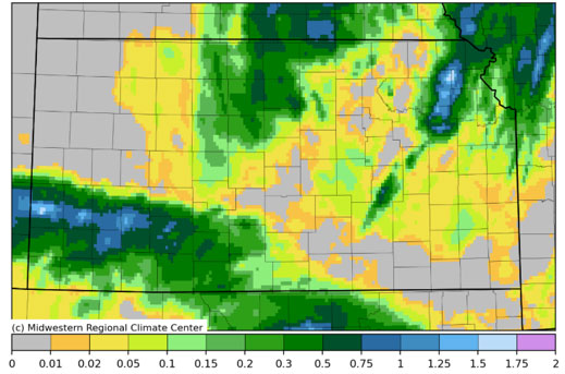
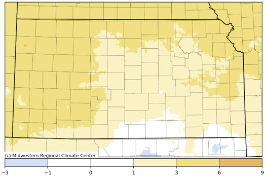
Figures 1a-b. Total precipitation (inches, top) and departure from normal temperature (°F, bottom) for the 7-day period (Sources: SRCC, HPRCC). (Note: these images occasionally contain erroneous data points which can significantly affect the contours.)
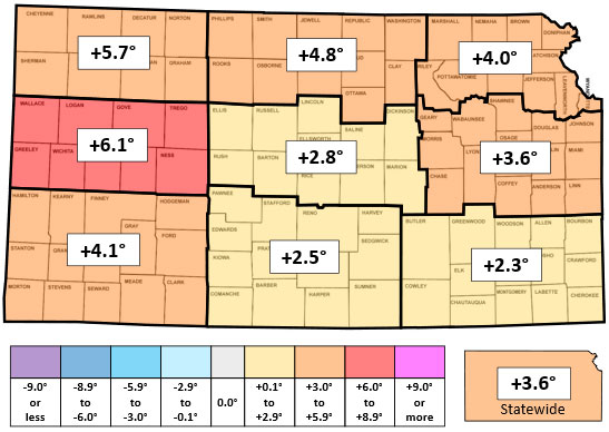
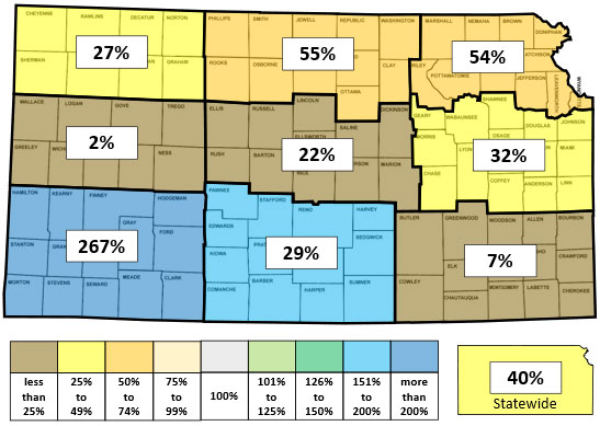
Figures 2a-b. This week’s departure from normal temperature (°F, top) and percent of normal precipitation (bottom) by Kansas climate division.
Drought
In the November 10 update of the US Drought Monitor (USDM), the only changes were one-category improvements in parts of 10 counties across southwest into south central Kansas (Figure 3). D1 was removed from portions of seven counties, while D0 was removed in six. Only 1.75% of the state is in D2 status, which includes parts of seven counties along the Oklahoma border. Coverage of D1 or worse (the official USDM definition of drought) in the state fell from 13.2 to 11.5 percent, the lowest percentage since late February. The Drought Severity and Coverage Index (DSCI) fell 2 points to 49.
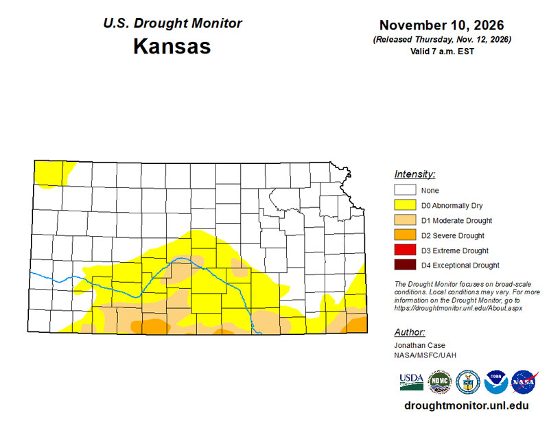
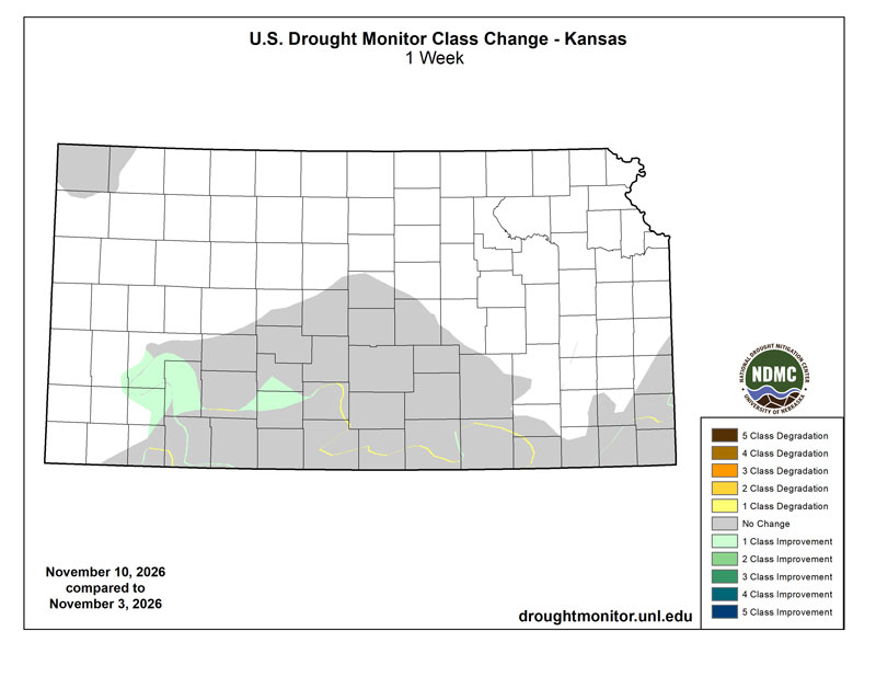
Figures 3a-b. Current weekly drought status (top) and change in category over the past week (bottom) for Kansas (Source: U.S. Drought Monitor).
Short- and Long-Term Outlooks
The Weather Prediction Center’s 7-day precipitation forecast, issued Wednesday morning and valid for the period November 11 through 18, calls for one-quarter to three-quarters of an inch of precipitation across southern Kansas, with the highest totals in south central Kansas along the Oklahoma border (Figure 4). Further north, lighter amounts under one-quarter of an inch are expected. Normal 7-day precipitation is 0.15” in western, 0.29” in central, and 0.49” in eastern Kansas. Temperatures are expected to average near to slightly above normal. November 11 is expected to be the warmest day, with a cooling trend thereafter. Areas in southeast Kansas that have yet to observe a fall freeze have the best chance of one on the morning of November 14. The average daily high and low for this period are 56° and 31°F.
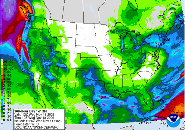
Figure 4. The National Weather Service Weather Prediction Center’s (NWS-WPC) 7-day precipitation forecast.
In the slightly longer term, the 8- to 14-day outlook, valid for the period November 18 through 24, above-normal temperatures are favored statewide, with increasing confidence from southwest to northeast (Figure 5). Probabilities range from 39 percent in the far southwest to 61 percent in extreme northeastern Kansas. In addition, there are unusually high probabilities for above-normal precipitation statewide. The highest probability is 68 percent in northeast Kansas, while the lowest probability is 57 percent in northwest Kansas.
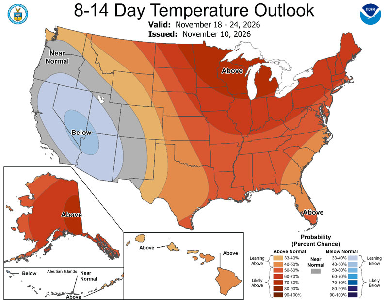
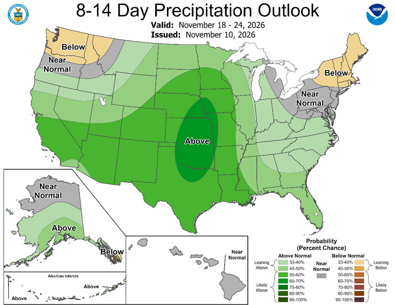
Figures 5a-b. The National Weather Service Climate Prediction Center’s (NWS-CPC) 8 to 14-day temperature (top) and precipitation (bottom) outlooks.
Looking even further ahead, the Climate Prediction Center’s weeks 3 and 4 outlook, issued on November 6 and valid for the 14-day period from November 21 through December 4, slightly favors below-normal temperatures (33 to 40 percent) in extreme southwestern Kansas (Figure 6). Above-normal temperatures are slightly favored across much of north central, northeast, and east central Kansas. Between these areas, there are equal chances of above-normal, below-normal, and near-normal temperatures. Above-normal precipitation is slightly favored across roughly the southern one-third of Kansas, with equal chances for above-, below-, and near-normal precipitation across the remainder of the state.
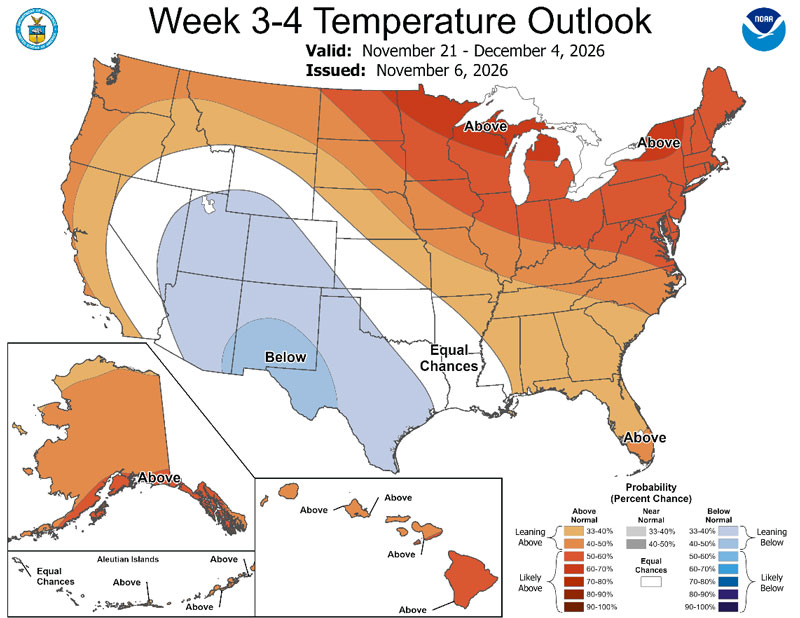
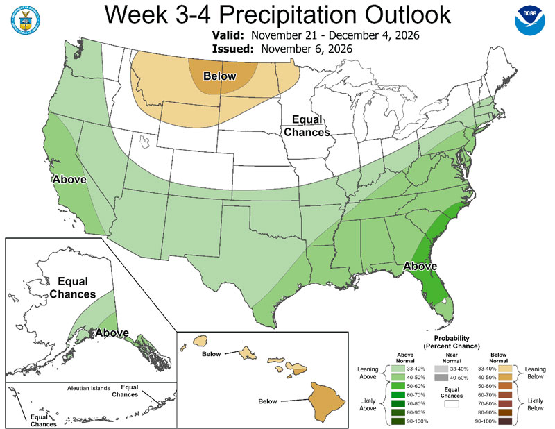
Figures 6a-b. The Climate Prediction Center’s weeks 3 and 4 outlooks for temperature (top) and precipitation (bottom).
Editor’s note: This article is a shortened version of a more comprehensive weekly climate and drought report. To receive the full report each week, please contact Matthew Sittel at the email below.
Matthew Sittel, Assistant State Climatologist
msittel@ksu.edu