First Freeze for Kansas: Running Behind Schedule This Year, Again
Around this time last year, I wrote an article entitled “Kansas’ First Freeze is Running Behind Schedule This Year”. This year, we are in a very similar position to last year, as we have yet to see a frost or freeze anywhere in the state so far this fall. That may be about to change.
Looking Back at Fall 2025
October is the month when most locations in Kansas experience their first fall freeze. Last year, the state’s first freeze occurred on October 18, when four Mesonet sites in western Kansas fell to as low as 30 degrees. It took three more weeks for the rest of the state to follow suit. On November 9, a very cold air mass overspread the state, and the first freezes were recorded prior to midnight. By the next morning, the entire state had fallen into the teens to the lower 20s, putting a definitive end to the growing season statewide. Prior to that November freeze, October had been unseasonably warm. October 2025 was Kansas’s 8th warmest October on record, dating back to 1895. Last October’s average temperature was 61.4°, or around 5 degrees above normal. So far in 2026, the average temperature for October 1-12 is 68.7°, or 8.6° above normal. This average is higher than the current record for the warmest October: 65.5°, set in 1963. We still have the second half of October to go, and with decreasing normal highs and lows each day, this month will likely finish cooler than where we are now.
Fall 2026
As of October 13, the coldest recorded in the state so far this fall is 39.4°, recorded at the Goodland Tech Farm Mesonet site on October 2. For most, the coldest temperature of the fall is in the 40s, but a few areas in southeast Kansas haven’t fallen below 50 (Figure 1). The normal lows for October 15 are in the 30s and 40s statewide (Figure 2), so the lack of 30s is unusual; the state’s average low through the first 12 days of October is 54.3°, or 7.5° above normal. The recent warmth is a continuation of above-normal conditions that dominated the month of September. Last month’s average temperature was 77.3°, an impressive 8.5° above normal, and was the warmest September on record, breaking the old mark of 76.7° set in 1931.
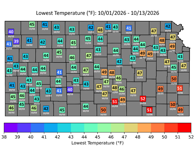
Figure 1. Coolest temperature recorded across the Kansas Mesonet this month, as of October 13. Plotted dates indicate the date (in MM-YY format) that the coolest readings were observed.
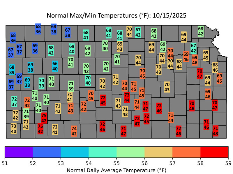
Figure 2. Average high and low for October 15. (Data source: NCEI)
Figure 3 shows the average date of the first fall freeze at dozens of sites across Kansas. A freeze is overdue in the northwest, and we are close to the average date for counties further east along the Nebraska border. While most locations typically record a first freeze in October, establishing the date of Kansas’s first fall freeze each year requires just one station to get that cold. The median data for Kansas’ first fall freeze based on 1991-2020 data is earlier than any individual location’s average: September 28. The record for the earliest occurrence of a first fall freeze is September 3. On that date in 1974, Cimarron, Lakin, and St. Francis all recorded lows of 29 degrees. The latest was in 1963, when it took until October 27 for a location to fall to the freezing mark. That year, it was Goodland that got there first by falling to 31 degrees. Last year ranks as the second latest; Goodland, as well as four Mesonet sites, recorded 2025’s first fall freeze on October 18, with the Hamilton County tower near Syracuse coldest at 30 degrees. Rounding out the top 5 latest list are 1923 (October 13), 1929 (October 12), and 1986 (October 11). Since we are still freeze-free through October 13, this year will rank in the top three as well. But where will it end up? That depends.
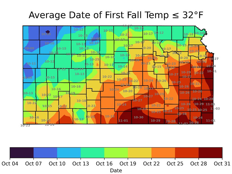
Figure 3. Average date of the first freeze, based on data from 1991-2020. Plotted dates indicate the average date (in MM-YY format) at various locations around Kansas. (Data source: SC-ACIS)
Short-Term Temperature Outlook
Kansas’s best chance for a freeze in the short term is expected this weekend. Saturday morning’s low temperatures are forecast to dip into the 30s across much of the state (Figure 4), but will it be cold enough for a freeze? The models aren’t in agreement on this possibility; some suggest southerly winds will keep temperatures above 32 degrees. Any wind would also preclude frost from forming. Either way, there is no threat of a hard freeze this weekend, and after Saturday, temperatures are expected to moderate, with above-normal readings returning to the area next week.
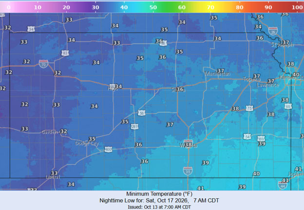
Figure 4. Forecast low temperatures across the state for Saturday morning, October 17. The data were obtained from the Weather Prediction Center’s National Digital Forecast Database, based on forecasts generated on Tuesday, October 13.
For those curious about the latest freeze on record at any individual location in Kansas, that title has been held in Montgomery County for over a century. Back in 1902, the town of Independence’s first fall freeze was on November 26. The year 1944 also featured a late end to the growing season at many locations; both Topeka and Wichita’s records for latest first freeze of the fall were set that year on November 21.
Matthew Sittel, Assistant State Climatologist
msittel@ksu.edu