Warm Temperatures: A Record-Setting September in Kansas
It’s time to turn the page on our calendars and begin the month of October. While I know many of us are remarking, “Where did the time go?”, you may also be thinking, “It doesn’t even *feel* like October yet!” You’re right! The lack of cool conditions so far this meteorological fall (which began on September 1) is, in many cases, unprecedented. In this report, we spotlight the unusually warm conditions this past month.
September Temperature Summary
The average temperature for September, based solely on data from the Kansas Mesonet, was 76.8°F. This average was 8.0° above normal for the month. While the official average temperature for September won’t be released by the National Centers for Environmental Information (NCEI) until October 8, if the official average matches the current Mesonet average, September 2026 will rank as the warmest on record (dating back to 1895), surpassing the old record of 76.7° set in 1931. Every day in September averaged above normal, continuing a run of warmer-than-normal conditions that began on August 24. This 38-day run (as of September 30) is the longest since a 44-day run in 2005-2006. Within that stretch, every day in January 2006 was above normal, making September the first time in 20 years to repeat that feat.
There is an even longer stretch still in progress: September 30 marked the 54th consecutive day when the average daily minimum temperature across Kansas was above normal. This is by far the longest run in the 41-year history of the Kansas Mesonet. Previously, the longest stretch of above normal average daily minimums was only 35 days, set in 1998 and again in 2011. This streak has resulted in a few firsts across the state, events that are, in some cases, unprecedented in climate records dating back more than a century.
Table 1 contains data for seven of Kansas’ longest-running climate sites. All of these locations have been observing daily high and low temperatures data since 1900 or earlier. All seven have achieved a remarkable feat this year: their lowest temperature in September was higher than in any other September in their respective climate histories. Here is a more detailed description of what happened, using Goodland as an example. The lowest temperature during September 2026 at Goodland was 50 degrees. It’s the first time Goodland has failed to fall below 50° in September in their 132-year climate history. The previous record for their warmest September minimum was 46° in 2019, and again in 2025. The normal low for September 30 at Goodland is 44°; they’ve been nowhere near that cold yet this fall. The previous record for the latest occurrence of the first fall low in the 40s at Goodland was September 25, 1963.
As for the other six sites in Table 1, the latest sub-50° occurrence at each location is in October, so a lack of 40s this fall is not a first. Wichita deserves mention here; they have yet to drop into the 40s or even the 50s this fall. This is a new record for Wichita, as the previous latest occurrence of their first fall low in the 50s was on September 16, 1980.
Table 1. Summary of September 2026 minimum temperature data at selected locations across Kansas, compared with historical extremes.
|
Location |
Sept 2026 Minimum Temp. (date) |
Record Warmest Sept Minimum (year) |
Normal Low for Sep. 30 |
Year climate records began |
Record for latest occurrence of first fall sub-50° low before 2026 (year, temp) |
|
Concordia |
56° (23) |
52° (2019) |
51° |
1885 |
Oct. 3 (2019, 46°) |
|
Dodge City |
54° (22) |
50° (1969, 2019) |
50° |
1874 |
Oct. 5 (1969, 43°) |
|
Goodland |
50° (27) |
46° (2019, 2025) |
44° |
1895 |
Sep. 25 (1963, 49°) |
|
Manhattan |
58° (23) |
55° (2019) |
51° |
1893 |
Oct. 8 (2025, 47°) |
|
Salina |
60° (23) |
52° (1998, 2004) |
52° |
1900 |
Oct. 10 (2015, 47°) |
|
Topeka |
58° (24) |
52° (2019) |
52° |
1887 |
Oct. 8 (1944, 46°) |
|
Wichita |
60° (23) |
55° (1998, 2019) |
54° |
1888 |
Oct. 19 (2025, 40°) |
The state’s coldest reading in September was just 49°, recorded on the 22nd in Gove County, and in Hamilton County on the 27th (Figure 1). Both lows were measured at Kansas Mesonet sites. The coldest reading at a long-term climate site is the aforementioned 50° at Goodland. Since 49° is the coldest so far this fall, a frost or freeze has not yet occurred anywhere in Kansas. Is the current lack of frost unusual? Not at all! Figure 2 shows the average first frost date across the state, using a first-low temperature of 36° as the threshold. Save for northwest Kansas, the first frost in the state is usually in October.
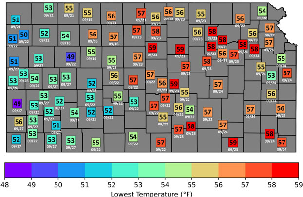
Figure 1. Lowest temperature recorded at each Kansas Mesonet site, along with the date of occurrence, during September 2026. Map by Matthew Sittel and Kansas Mesonet.
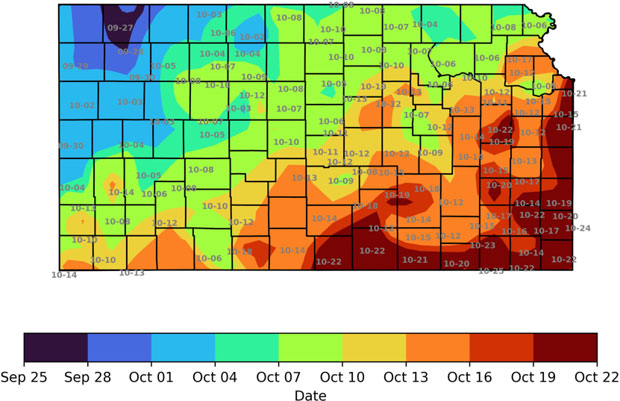
Figure 2. Average date of the first frost in Kansas, based on data from official climate sites. Map created by Matthew Sittel.
The extended outlook does not suggest that cold air will arrive anytime soon. However, more seasonable conditions are on our doorstep. Many locations across the state will record their coolest morning of the fall tomorrow (Oct. 2), as lows are forecast to dip into the 40s Friday morning across western Kansas. We can thank Hurricane Polo for the arrival of autumnal readings. Polo not only brought generous amounts of rain to Kansas, but its remnants will also pull cooler air down from the north as it moves away. Across eastern Kansas, while the coolest temperatures so far this fall are also expected this weekend, lows will be in the 40s and 50s; it will not get cold enough for frost. It is difficult to pinpoint exactly when the first frost will occur. Predicting the exact date, possibly 2 to 4 weeks away, is beyond the skill of any forecast model. Still, this coming cooldown is a sure sign of progress towards the state’s first frost.
Matthew Sittel, Assistant State Climatologist
msittel@ksu.edu