Using Drones for In-Season Corn Crop Scouting
During the growing season, it is critical to monitor fields regularly. Most Kansas corn fields are at the late vegetative growth to tasseling (VT) stages right now, depending on location, which are critical for determining final yield. During the transitional phase from vegetative to reproductive development (VT), stresses such as drought, flooding, disease, pests, and nutrient deficiencies may reduce kernels per ear, lower test weight, and ultimately lower crop yield. Therefore, proper monitoring during this phase can help with early stress detection and crop yield estimation.
RGB or natural-color images and multispectral-based vegetation indices (VIs), such as the Normalized Difference Vegetation Index (NDVI) and the Normalized Difference Red Edge Index (NDRE), can be used to monitor crop and crop vigor during the in-season period.
Using Drone Imagery to Identify Crop Variability Within a Field
Drone imagery was collected during the tasseling stage of corn in Shawnee, KS, and an RGB image was used to monitor the crop. This field consisted of different green- or yellow-light patches or plastic areas, which were ground-truthed as sulfur-deficient.
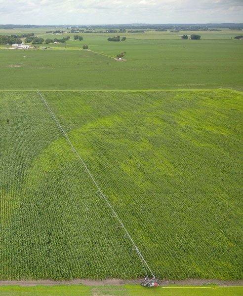
Figure 1. Natural or true color image collected using an RGB camera on the drone. The yellowish patches in the field were identified. Such drone images can help visualize the problematic areas of the field. This field is considered to have a sulfur deficiency. Photo by Deepak Joshi, K-State Extension.
Similarly, drone-based multispectral imagery can help identify differences in crop growth that may not be obvious from the field edge. The maps shown in Figure 2 below are NDVI and NDRE maps from a 59-acre field at Flicker Innovation Farm in McPherson County. The high-resolution drone imagery, with a pixel size of 3.94 inches, was collected on July 29, 2026, at around the tasseling growth stage to create NDVI and NDRE maps.
In these maps, green areas represent relatively higher vegetation-index values, while yellow, orange, and red areas represent progressively lower values. Most fields have moderate-to-high NDVI and NDRE values, indicating generally uniform and healthy crop growth. However, there were some lower-value areas along the field boundaries and in scattered locations within the field. These areas may be associated with reduced crop stands, exposed soil, water stress, nutrient limitations, weed pressure, disease, compaction, or other issues. Therefore, manual targeted scouting will help understand the real issue, resulting in lower vegetation index values.
NDVI is widely used to evaluate crop emergence, canopy cover, and overall plant vigor. However, it can become less sensitive once the crop develops a dense canopy. NDRE uses the red-edge portion of the spectrum and can provide additional information about variation in chlorophyll content and crop condition during later growth stages. Using NDVI and NDRE together can therefore provide a more complete picture of within-field crop variability.
These maps should not be interpreted as direct diagnoses. Instead, they can be used to guide field scouting and identify the problematic areas. Producers and crop consultants can visit problematic areas identified using RGB, NDVI, and NDRE imagery, compare them with healthier areas, and determine which management decisions are needed.
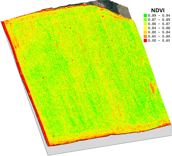
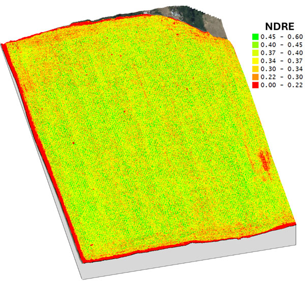
Figure 2. Drone-derived NDVI (top)and NDRE (bottom) maps showing spatial variability in crop canopy condition within the field. Green areas indicate relatively higher vegetation-index values, while yellow, orange, and red areas indicate lower values. Lower values near field boundaries may partly reflect exposed soil, mixed pixels, or image-edge effects and should be verified through field scouting. Because NDVI and NDRE use different numerical ranges, colors should be interpreted using the legend for each map rather than comparing them directly.
Conclusion
Drones have huge applications in agriculture on our farm for our in-season crop monitoring and scouting. For these drones, different types of sensors or cameras can be used, each providing varying levels of information and accuracy. The RGB sensor provides a real human-eye view from the sky and can provide general information about the crop. A multispectral sensor drone can provide more detailed information by detecting reflections of light that are not even visible to the human eye. However, drone-based images should not be interpreted as direct diagnoses. Instead, they can be used for target-field scouting, ground truthing, and identifying real problems.
Deepak Joshi, Precision Ag Extension Specialist
drjoshi@ksu.edu
Eric Adee, Agronomist-in-Charge, River Valley and East Central KS Experiment Fields
eadee@ksu.edu
Logan Simon, Southwest Area Agronomist
lsimon@ksu.edu
Tina Sullivan, Northeast Area Agronomist
tsullivan@ksu.edu